Wednesday, June 19, 2013
Friday, June 14, 2013
Exam Review for the Exam on Thursday June 20th at 9:00am!
Be familiar with the following material covered during the
course. Be sure to utilize past tests and assignments as study aids.
Map of Canada- know your provinces, capitals, waterways
Mapping Skills
-read grid (4 point and 6 point
military)
-direction (bearings and
cardinal points)
-latitude/Longitude
(tropics/poles/meridians/dateline,etc)
-contours
-symbols
-scale/distance (3 types)
Population
-distribution
-density
-Population pyramid
-demographic terms
-urbanization
-urban hierarchy
-urban land uses
Landform
Regions of Canada
Geological Eras
-era each landform was created
in
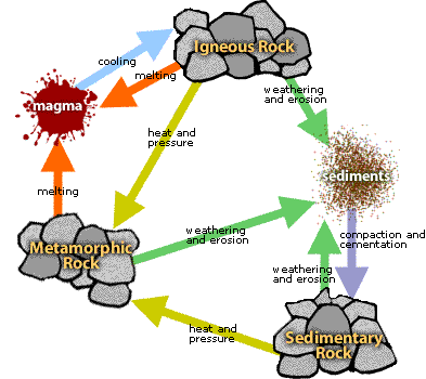
-types of rocks found in
landform region (Igneous, metamorphic, sedimentary)
-what eras did live appear
(plant life, reptiles, animals, humans, etc)
Rock Cycle
Climate-
types of precipitation
Sustainability
Ecological
footprint
Natural
Resources
-renewable/non-renewable
Tuesday, June 11, 2013
Class Survey!
I hope you've enjoyed your geography class this semester! I've had a lot of fun learning with you, and hopefully you believe me that Geography can be fun and you can connect EVERYTHING to the study of Geography!!
Please take a moment and complete a survey about your Geography Class!

Please take a moment and complete a survey about your Geography Class!
Thursday, June 6, 2013
Wednesday, May 29, 2013
Test Tomorrow! Here's what you need to review!
Map projection
Types of maps (general purpose, thematic and topographic)
Latitude/Longitude (meridians, tropics, international dateline, etc)
Time zones in Canada
all components of a map
direction (cardinal points and bearings)
scale (verbal, linear and RF-representative fraction)- know how to calculate real-world distance and do the conversions
4 point grid and 6-point military grid
topographic maps
-symbols
-contour lines-profiles
-GPS how it works
Friday, May 3, 2013
Tuesday, April 30, 2013
Google Maps & Outside!!
Thursday we're planning to go outside for the period--dress appropriately!
Here is the Google Maps link we'll be using on Wednesday for our activity. https://maps.google.ca/
It's best to use Google Chrome to open maps.

Here is the Google Maps link we'll be using on Wednesday for our activity. https://maps.google.ca/
It's best to use Google Chrome to open maps.
Sunday, April 21, 2013
Please take a moment to take this survey!
Please complete this survey so I can have a better idea of the devices you have. You will use your hdsb login (what you use to log into the computers at school) to log into the survey.

Thursday, April 18, 2013
Natural Systems Test Review (Vegetation, Soil & Climate)--Test Wednesday April 24th
Vegetation & Soil
in Canada
-soil profile
-parts of soil, how it becomes part of the soil, what does
it do in the soil
-Vegetation Region (types of vegetation and precipitation in
some of the regions (logical))
Climate Regions of
Canada
Weather vs climate
Factors affecting climate (LOWERN) – understand how they
affect both temperature and precipitation
Types of precipitation (Orographic/relief, convectional,
frontal/cyclonic)- be able to draw and
label a diagram for each
Chinook
Lake Effect (isolated weather conditions – ie cooler near
the lake, lake effect snow, precipitation, etc)
Wind – jet stream, high and low pressure areas
El Nino (from Ice storm reading)
Climate Graphs (averages, temperature range, seasonal
distribution, continental vs maritime climate)
Understand how to read a climate graph and identify a
maritime vs continental climate region

Tuesday, April 16, 2013
Climate Power Points
Here is the powerpoint we covered to introduce the unit.
Here is the powerpoint on the factors affecting climate (LOWERN)
Here is the powerpoint on the factors affecting climate (LOWERN)
Climate Culminating Activity
You guys are off to a great start researching the weather for your chosen region in Canada. Be sure to access this website http://www.theweathernetwork.com/statistics/ from the Weather Network for some statistics for your city.
Remember you are making up the forecast for 3 days for your location for any given month based on the averages the factors affecting the climate in that region.
You have a few options for delivering your weather forecast:
1. Create a video using your smartphone technology or cameras and provide me with the file
2. Create a video in the same manner and show it to the class
3. present in front of the class using the smartboard for any maps, visuals, etc.
4. present in front of me at lunch time using the smartboard for any maps, visuals, etc.
Thursday, April 11, 2013
Here's the Ice Storm Weather Warning for Today! Notice the key words
Potential for a major ice storm.
Periodic light rain is affecting the area this morning, but a more
wintery change is on the way. Colder air is arriving and will coincide
with an approaching low currently over Illinois. A messy mix of ice
pellets and freezing rain is expected to develop early this morning in
the warned regions and become predominantly freezing rain later this
afternoon and tonight. It may very well fall heavy at times and be
accompanied by a few rumbles of thunder.
Poor travel conditions are expected over the duration of this event. In
particular, the morning commute may be challenging with icy conditions
on untreated roads, especially for areas near and west of the Greater
Toronto area to Lake Huron. And it may be even more problematic for the
evening rush hour. Of greater concern is the risk of widespread power
outages from downed tree limbs and power lines due to significant ice
accumulation combined with northeast winds gusting to 60 km/h. Freezing
rain amounts up to 10 mm are quite possible in many areas with some
regions possibly exceeding 20 mm.
It should taper off by Friday morning with temperatures rising above
freezing.
There is still some uncertainty as to the extent of the cold air. This
will have an impact on how much falls as ice pellets versus freezing
rain. Freezing rain will have a higher impact with power outages and
slippery roads and sidewalks. Although a few centimetres of ice pellets
is possible, it is more of a nuisance for travel rather than a serious
hazard.
Monday, April 1, 2013
Wednesday, March 20, 2013
Test Review
Test Review
Be prepared for the physical
geography test for Tuesday March 26th!
Here is what you should be familiar with:
-super continent
-wegener's theory
-layers of the earth
-folding (monocline, syncline, anticline)
-faulting (diverging, converging, subduction, rift valley,
slip/strike)
-be prepared to label diagrams that may include types of folding,
faulting and earthquake activity
-identify the 4 types of volcanoes we looked at and know the
characteristics of each
-know the definitions to the terminology we looked at for
volcanoes (lahar, pyroclastic, tephra, magma, lava, etc)
-rock cycle
-what forces changed the landscapes
(erosion, etc)
-have an idea of where each landform
region is in Canada
-characteristics of each region
-types of rocks (igneous, metamorphic,
sedimentary) and natural resources found in each region
-geological eras- what parts of Canada formed
first and last (Canadian Shield to the Western Cordillera)
-characteristics of each era
-what region do we find most of our oil
and natural gas
Good luck!

Sunday, March 17, 2013
Friday, March 15, 2013
Geological Eras and the end of our unit!
Welcome back from March Break!! We're finishing off our Physical
Geography unit with Geological Eras and our culminating activity!
Here is the powerpoint we'll cover on Monday
Here is the chart we'll fill out
Here is the assignment and rubric! Due date Wednesday March 27th.
Homework over the break should have included finishing up the Landform Regions Map from p. 131, and completing a list of the characteristics using the handout (two physical and two human) (or textbook if you took one home).
Test: Tuesday March 26th
Wednesday, February 27, 2013
Dante's Peak plus Volcano Power Point
We're watching Dante's peak this week. Check out this link to a Q & A page about the realities of the movie... pretty neat!
Here's our Volcano Power Point from class
Also...
List of the most current earthquake activity
Measure tectonic plate movement anywhere in the world. Just type in a coordinate (long & lat) Don't worry about seconds or any other information... if you have the lat and long, it will tell you.
Here's our Volcano Power Point from class
Also...
List of the most current earthquake activity
Measure tectonic plate movement anywhere in the world. Just type in a coordinate (long & lat) Don't worry about seconds or any other information... if you have the lat and long, it will tell you.
Sunday, February 24, 2013
Physical Geography PowerPoint
Here is our Power Point that has covered the following in class:
Plate Tectonics
Earth's Layers
Folding & Faulting
Earthquakes
Plate Tectonics
Earth's Layers
Folding & Faulting
Earthquakes
Friday, February 22, 2013
Tuesday, February 19, 2013

Monday, February 11, 2013
Tectonic Plates Article & Questions for homework-due tomorrow
Check out the cool National Geography Map, which you can overlay things like volcanoes, earth quakes and tectonic plates!
Sunday, February 10, 2013
Article Analysis due tomorrow
Your article analysis is due tomorrow. If you forgot the outline, here it is! Be sure to attach a copy of your article!
See you tomorrow for another short week!
See you tomorrow for another short week!
Tuesday, February 5, 2013
Welcome!
Welcome to Gr. 9 Academic Geography!! Looking forward to getting to
know all of you and sharing the wonderful world of geography with you!!
Subscribe to:
Posts (Atom)