Gr. 9 Academic Geography
Due Dates
Due Dates
Map of Canada--Friday February 8th
Map of Canada Quiz--Wednesday February 20th
Article Analysis--Monday February 11th
Tectonic Plates Puzzle--Tuesday February 19th
Physical Geography Unit Test--Tuesday March 26th
Geological Eras Project--Wednesday March 27th
Climate Test-- Wednesday April 24th
Weather Report-- Thursday April 25th - revised to Wednesday May 1st
Mapping Test- Thursday May 30th
Island Design Assignment --Monday June 3rd
EXAM-- Thursday June 20th @ 9:00am
Wednesday, June 19, 2013
Friday, June 14, 2013
Exam Review for the Exam on Thursday June 20th at 9:00am!
Be familiar with the following material covered during the
course. Be sure to utilize past tests and assignments as study aids.
Map of Canada- know your provinces, capitals, waterways
Mapping Skills
-read grid (4 point and 6 point
military)
-direction (bearings and
cardinal points)
-latitude/Longitude
(tropics/poles/meridians/dateline,etc)
-contours
-symbols
-scale/distance (3 types)
Population
-distribution
-density
-Population pyramid
-demographic terms
-urbanization
-urban hierarchy
-urban land uses
Landform
Regions of Canada
Geological Eras
-era each landform was created
in
-types of rocks found in
landform region (Igneous, metamorphic, sedimentary)
-what eras did live appear
(plant life, reptiles, animals, humans, etc)
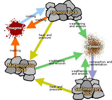
Rock Cycle
Climate-
types of precipitation
Sustainability
Ecological
footprint
Natural
Resources
-renewable/non-renewable
Tuesday, June 11, 2013
Class Survey!
I hope you've enjoyed your geography class this semester! I've had a lot of fun learning with you, and hopefully you believe me that Geography can be fun and you can connect EVERYTHING to the study of Geography!!
Please take a moment and complete a survey about your Geography Class!

Please take a moment and complete a survey about your Geography Class!

Thursday, June 6, 2013
Urbanization/ Land Uses PowerPoint
Here is our Urbanization/Land Uses PowerPoint from Class today!
Wednesday, May 29, 2013
Test Tomorrow! Here's what you need to review!
Map projection
Types of maps (general purpose, thematic and topographic)
Latitude/Longitude (meridians, tropics, international dateline, etc)
Time zones in Canada
all components of a map
direction (cardinal points and bearings)
scale (verbal, linear and RF-representative fraction)- know how to calculate real-world distance and do the conversions
4 point grid and 6-point military grid
topographic maps
-symbols
-contour lines-profiles
-GPS how it works
Friday, May 3, 2013
Latitude & Longitude
Click here to learn about latitude & longitude!
Tuesday, April 30, 2013
Google Maps & Outside!!
Thursday we're planning to go outside for the period--dress appropriately!
Here is the Google Maps link we'll be using on Wednesday for our activity. https://maps.google.ca/
It's best to use Google Chrome to open maps.

Here is the Google Maps link we'll be using on Wednesday for our activity. https://maps.google.ca/
It's best to use Google Chrome to open maps.
Subscribe to:
Comments (Atom)